São Tomé and Príncipe
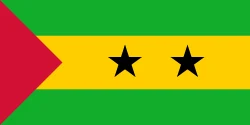
São Tomé and Príncipe is in Africa, in the Central Africa region. Its capital is São Tomé. It has a population of about 240,254 and an area of 964 km². Its flag has 4 colors, and the one that takes up the most space is light green, at 53.2% of the total.
The flag of São Tomé and Príncipe as a pie chart
- Light green 53.2%
- Yellow 32%
- Red 12.6%
- Black 2.3%
- Design
- Complex design (cross, diagonal, triangle or canton)
- Symbol
- Has stars
Each slice shows how much of the flag each color covers. It's the same data as CakeFlag, our game where you guess countries from the colors of their flag.
São Tomé and Príncipe at a glance
- Capital
- São Tomé
- Continent
- Africa
- Region
- Central Africa
- Official languages
- Portuguese
- Currency
- São Tomé and Príncipe dobra
- National day
- July 12
- Highest point
- Pico de São Tomé (about 2,020 meters)
- Anthem
- “Independência total”
- Area
- 964 km²31st smallest out of 208
- Population
- 240,25426th least populous out of 204 · 2025 data
- Population density
- 249.2 people/km²48th most densely populated out of 204 · 2025 data
- GDP
- US$ 981.3 million9th lowest GDP out of 200 · 2025 data
- GDP per capita
- US$ 4,08463rd lowest GDP per capita out of 200 · 2025 data
- Life expectancy
- 69.9 years63rd lowest life expectancy out of 204 · 2024 data
More facts
- Became independent from Portugal
- Joined the UN in 1975
- The Equator runs through it
Neighboring countries
São Tomé and Príncipe has no land borders with other countries.
Would you recognize it in a game?
Data: World Bank, world-countries, Wikidata and CIA World Factbook. See all sources.