Madagascar
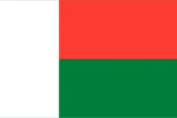
Madagascar is in Africa, in the East Africa region. Its capital is Antananarivo. It has a population of about 32.7 million and an area of 587,041 km². Its flag has 3 colors that take up the same space: green, red, and white, at 33.3% each.
The flag of Madagascar as a pie chart
- Green 33.3%
- Red 33.3%
- White 33.3%
- Design
- Complex design (cross, diagonal, triangle or canton)
- Symbol
- No coat of arms or symbols
Each slice shows how much of the flag each color covers. It's the same data as CakeFlag, our game where you guess countries from the colors of their flag.
Madagascar at a glance
- Capital
- Antananarivo
- Continent
- Africa
- Region
- East Africa
- Official languages
- French and Malagasy
- Currency
- Malagasy ariary
- National day
- June 26
- Highest point
- Maromokotro (about 2,880 meters)
- Anthem
- “Ry Tanindrazanay malala ô!”
- Area
- 587,041 km²46th largest out of 208
- Population
- 32.7 million49th most populous out of 204 · 2025 data
- Population density
- 55.8 people/km²68th least densely populated out of 204 · 2025 data
- GDP
- US$ 19.6 billion64th lowest GDP out of 200 · 2025 data
- GDP per capita
- US$ 5994th lowest GDP per capita out of 200 · 2025 data
- Life expectancy
- 63.8 years22nd lowest life expectancy out of 204 · 2024 data
More facts
- Became independent from France
- Joined the UN in 1960
- Lies entirely in the Southern Hemisphere
Fun facts about Madagascar
Featured in GeoFacts #32
- In a local tradition, people dig up their dead, wrap them in new cloth and dance with them. Source: Wikipedia (ES) - Famadihana
- About 90% of its plants and animals exist nowhere else. Source: Wikipedia (EN) - Wildlife of Madagascar
- It's the island of lemurs, and an animated film is named after it. Source: Wikipedia (ES) - Madagascar (película)
Neighboring countries
Madagascar has no land borders with other countries.
Would you recognize it in a game?
Data: World Bank, world-countries, Wikidata and CIA World Factbook. See all sources.